

Location:
Khirbat as-Sar (Sara) is a site in the southwest part of "the land of the children of Ammon," b'ne Ammon (Judges 11.13). This biblical narrative generally refers to the Amman Plateau (in more recent times also known as the Belqa, or "empty" land), a territory inhabited by a semi-nomadic people that became an independent tribal kingdom of Ammonites at the turn of the 2nd and the 1st millennium BC. Today, the site is located on the western outskirts of Amman, between wadis descending towards the south and west, from the later 8th century. BC on, this region belonged in turns to the empires of Assyria (as a vassal kingdom), Babylonia and Persia, the Ptolemies, Seleucids, Hasmoneans, the Romans, and Byzantines, until its conquest by the Muslims in AD 636.
Khirbet es-Sar in the accounts of 19th and 20th century travellers
The first reference to the site as "Khurbet Sar" was made in 1877 r. by S. Merrill (1881, 404-405), who situated it in the Jazer region ("Jazer plateau") to the west of Amman ("the great plateau north and east of Sar"), where "Wady esh Shita descends rapidly on the south". Soon after that, in 1881, it was visited by C.R. Conder (1889, 153), who described it as a large site on "the ancient west road from Amman." By the northern side of this road, "six sarcophagi were found lying in a square enclosure," which must be a reference to a built tomb outside the limits of the settlement. Conder describes the tower as built "of great blocks of chert or flint." To the east of it, he notes "remains of a building with two parallel rows of arches," remarking that "the piers beneath the arches are covered up" which means that the appearance of the courtyard has not changed since the 19th century till now. He notes that "the face of each arch is ornamented with moldings (as in the structural tombs of Amman)," supposing that the building had a funerary function. He also mentions "a large pool or Birkeh in the ruins" and "masonry of Roman appearance" and concludes by assigning a Roman date for the site.
,_ill._21.jpg)
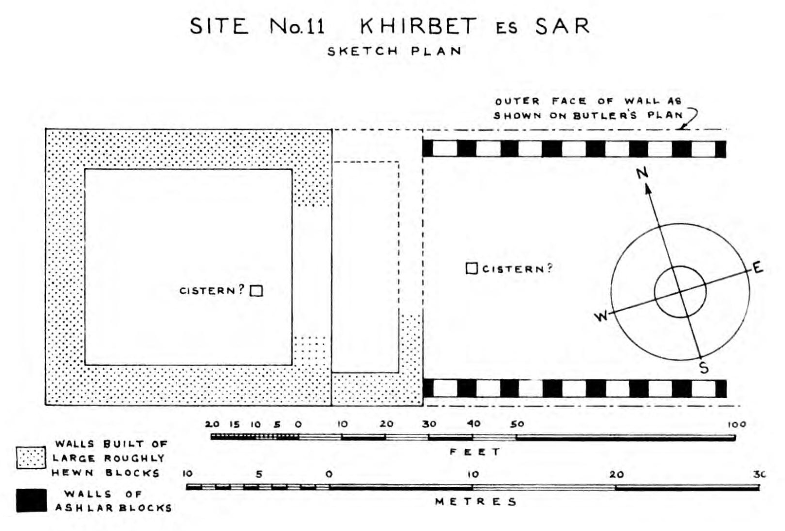
The next visitor to Khirbat as-Sar, in 1905, was H.C. Butler (1919, 33, ill. 21), who specified that it was situated "at the very top of the mountain range between the Wadi is-Sir and the Wadi Amman". His description focused on the square structure (the "qasr") "surrounded by a mass of broken and half-buried walls of rude workmanship and various ages, from the period of considerable antiquity to a comparatively late Mohammedan date." He noted dimensions and appearance of the central structure "of great antiquity, probably a shrine, which was renovated or restored by builders of the Roman period" as well as a courtyard to the east of it, flanked by two rows of arcades (called by him arcosolia), seven arches in each row.
,_fig._54.jpg)
In 1937, the site was visited by N. Glueck (1939, 153-56, site no. 207), who knew it by the name of "Qasr es-Sar". In his topographical description, Glueck emphasizes the strategic qualities of the site, which "nears the w. edge of the plateau overlooking the descent to the Jordan River valley" (…). "Situated at the top of the gradual slope from the east to the west, at a height of 972 m, it occupies the highest point in the vicinity and commands an excellent view over much of the surrounding countryside". In Glueck's opinion, the square structure was built as a fortress, which was transformed by the Romans into (presumably) a temple by adding a "platform" on its eastern side, preceded by the arcaded courtyard. Other site elements mentioned by Glueck were "numerous large, now filled-up cisterns and cave cisterns around the site," as well as "remains of considerable settlement on the s.e. side of the qasr, and also on the n.e. side, where there are also the remains of the small reservoir”.
It is also noteworthy that the "Ammonite tableland" was of interest to Sir Flinders Petrie's expedition. In 1938, after his last campaign in Gaza, two team members explored several ruins near Amman, mainly those with the remains of towers. Among them was Khirbet es-Sar (Sites 11 and 12). In addition to the description, they included four photographs and a sketch of the tower and arcades (Petrie 1952, 41, XLVIII, L: 14-17).
It is interesting to note how Petrie himself interpreted the remains of the arcades:
„ a hall about 60 ft. long, with seven windows in each side. These are round-headed, with a continuous moulding (…). This can scarcely be anything but a church. At the west end is a square building with pieces of columns, and a cistern, and this is evidently the baptistery, separate as in early Italian churches. The date is indicated by pottery scattered around, of about A.D. 300. This was, then, a church of Constantine age, ruined by the Arab invasion”.
Petrie 1952, 39
Identification of the site
The site's ancient identity remains obscure. Merrill (1881) and Conder (1889) would identify it with the biblical Jazer. C.R. Conder (1889) maintained this view, stating that the site was probably the same as Azor in the Onomastikon of Eusebius of the 4th century AD (s.v. Azōr (Iazer):
"Boundary of the children of Ammon" (border city of Ammon) which is called Philadelphia now. (…). There is eight miles (about) from Philadelphia a village Azer (Iazer) remaining today.”
translated by C. Umhau Wolf 1971: http://www.tertullian.org/fathers#onomasticon

Indeed, the geographical situation and some archaeological evidence for habitation during the Hellenistic period might suggest the identity of Kh. Sar with the fortified settlement of Jazer, conquered by Judah Maccabee in 163 BC (I Macc. 5,8). Under the Ptolemies, in the 3rd century. BC, the site must have been part of the region administered by the mighty family of Tobiads, suggesting its possible identification with "Birta of the Ammanitis," mentioned in a letter from the Zeno Archive, dated to 259 BC. (see discussion in Młynarczyk, Burdajewicz 2018, 359-360).
Bibliography:
Butler, H.C. (1919). "Syria: Publications of the Princeton University archaeological expeditions to Syria in 1904–5 and 1909. Division II: Architecture, Section A: Southern Syria." Leiden: E.J. Brill
Conder, C.R. (1889). "The survey of eastern Palestine." London: Committee of the Palestine Exploration Fund
Glueck, N. (1939). "Explorations in Eastern Palestine III (AASOR18–19)." New Haven, CT: American Schools of Oriental Research
Merrill, S. (1881). "East of the Jordan: A record of travel and observation in the countries of Moab, Gilead and Bashan." New York: Charles Scribner’s Sons
Młynarczyk, J. and Burdajewicz, M. (2018). "Archaeological and geophysical survey at the site of Khirbat as-Sar (Sara), Jordan." Polish Archaeology in the Mediterranean 27/1, 341-378
Petrie W. M. F. (ed.) (1952). "City of Shepherd Kings, Ancient Gaza V." London: Quaritch
Umhau Wolf, C. (1971). "The Onomasticon of Eusebius Pamphili - Compared with the Version of Jerome and Annotated."